


Charts
Korea Ocean Development is CHART and sailing sectors for more than 40 years established in 1973. It also provides the most comfortable and accurate service to retain professional staff. Korea Ocean Development offers a variety of products, such as South Korea, the UK, Japan, USA, Australia, and can hold more than about 50000 species of inventory always provide the most up-to-date chart.
Korea Charts
Issued by CHART depth in KHOA, reefs, coastlines, and aids to navigation such as navigators and making the information to the IHO standards, projection point typically uses the projection. Geographic longitude of CHART, Latitude is manufactured based on the World Geodetic System (WGS84).
ADMIRALTY Charts
ADMIRALTY Standard Nautical Charts comply with Safety of Life at Sea (SOLAS) regulations and are ideal for professional, commercial and recreational use.
Charts within the series consist of a range of scales, useful for passage planning, ocean crossings, coastal navigation and entering port.
Mariners should always use the largest scale nautical chart appropriate to their needs. In particularly busy seaways such as the English Channel, Gulf of Suez and the Malacca and Singapore Straits,
the standard nautical charts are supplemented by mariners' routeing guides which provide advice on route planning in these complex areas.
Australian Charts

The Australian Hydrographic Service (AHS) is part of the Royal Australian Navy which is responsible for providing Australia's national charting service under the terms of the UN Safety of Life at Sea (SOLAS) Convention and the Navigation Act.
They publish and maintain the national chart series (nearly 400 navigational charts).
Japanese Charts
The Japanese Coast Guard produces nautical charts to cover the Japanese coasts,
Pacific and Indian Oceans and their adjacent seas.
Pacific and Indian Oceans and their adjacent seas.
Print on Demend(POD) Charts
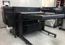
Chart name will be displayed as the label on the back. SMALL CORRECTION newest first came to the quality of the chart, such as chart is available.
POD chart is normal Chart passing through the inspection and testing of the watercourse part, it can be used with existing chart.
Korea Ocean Development offers the UKHO and NOAA to POD services.