


- Global ENC coverage with more major routes and ports than any other competing service
- Carriage-compliant ENCs with certification to aid Port State compliance
- Operates on all ECDIS makes
- Unique ADMIRALTY Information Overlay (AIO) for additional
passage planning information - Weekly updates available electronically
- Online version now available for shore-based activities
Electronic Charts/Publication
Have the expertise and know-how of paper Chart, ENC, surge committed to safe navigation committed to provide. It also operates in the team so that you can easily configure the ENC to switch from the existing chart.
01 Why AVCS?
AVCS helps your bridge officers to navigate safely and efficiently, and helps to keep your ships compliant with Flag and Port State Authorities. Capitalising on the UKHO’s expertise and position as a leading provider of nautical paper charts, AVCS also incorporates the unique AIO, helping to simplify passage planning.
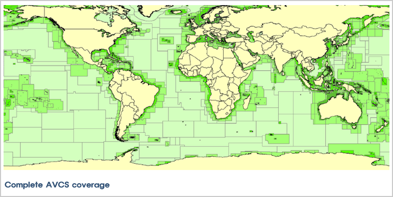
02 More routes, more ports
AVCS provides the widest carriage-compliant coverage, allowing ships to navigate on ECDIS for the entirety of most major routes on a single chart service. AVCS also includes over 4,000 of the biggest and busiest ports, terminals and fields worldwide, of which we offer unique coverage for over 70.
03 Carriage-compliant ENCs
All ships using AVCS on board receive a UKHO certificate. This certificate confirms that all ENCs in AVCS satisfy the chart carriage requirements of SOLAS Chapter V, and can be used for local inspection. AVCS meets the latest mandated data protection standards, S-63 Edition 1.2 from the International Hydrographic Organization (IHO). This helps to reduce the risk of both data piracy and the distribution of dangerous ENCs that do not comply with IHO standards.
04 Ongoing safety and compliance
All AVCS customers receive weekly ENC updates. Installing the latest updates on a regular basis supports safe navigation and compliance with Flag and Port State requirements.
05 Optimised chart holdings
For maximum conv enience AVCS ENCs can be ordered in predefined transit, regional or port folios (groupings of ENCs). New ENCs are automatically added to folio holdings as soon as they become available, ensuring ships always have the latest data within their chosen level of coverage. Alternatively, all ENCs can be bought on an individual, chart-by-chart basis for precise coverage and voyage flexibility. Simply buy the licences to unlock the charts needed for a voyage – when and for as long as they are needed. Most ENC-issuing countries allow durations of 3, 6, 9, or 12 months.

- Familiar, clear and easy to use digital charts
- Extensive coverage of international routes and ports
- Free weekly ADMIRALTY Notices to Mariner updates
- Cost-effective digital charting for shore-based applications
01 Global coverage
With over 3,000 official charts available, ARCS provides extensive raster chart coverage of international shipping routes, main ports and harbours in a comprehensive range of scales. By combining the wide coverage, familiarity and ease-ofuse of ARCS with ADMIRALTY Vector Chart Service (AVCS), you get the most comprehensive and trusted digital chart service available for ships trading internationally.
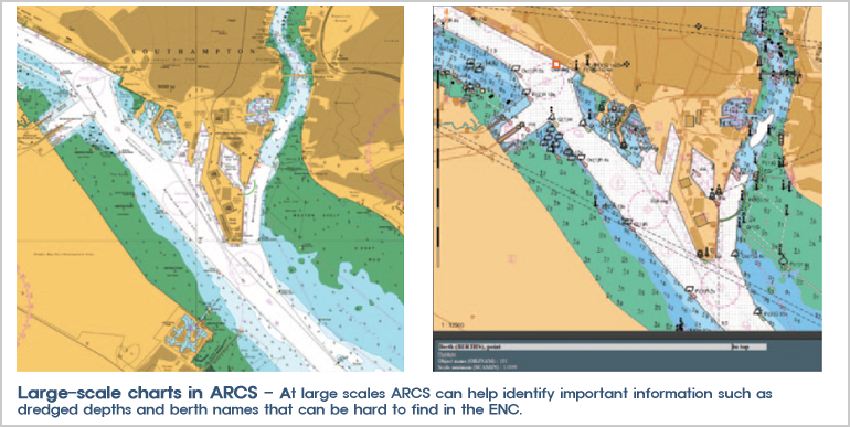
02 Official Raster Navigational Charts
Raster Navigational Charts (RNCs) are a safe and reliable primary navigation alternative under certain conditions and subject to individual Port and Flag State approval, for example where ENCs don’t yet exist (see IMO resolution MSC 86 (70). ARCS is an RNC service containing digital raster copies of official ADMIRALTY paper charts, conforming to the International Hydrographic Organization (IHO) Product Specification S-61.
03 Efficient weekly updates, including T&P NMs
Weekly updates ensure that bridge officers have access to complete and up-to-date information. All ARCS customers can receive these updates via internet or disc, with the latest ADMIRALTY Notices to Mariners (NMs) applied easily and accurately in a matter of seconds. The weekly updates also include Temporary and Preliminary Notices to Mariners (T&P NMs) generated by the UKHO’s extensive quality assurance processes.
04 Synchronised weekly chart updates for simplicity
The weekly updates for ARCS synchronise with the latest ADMIRALTY paper chart weekly Notices to Mariners, complete with matching reference numbers. This means less complexity and confusion on the bridge with ships also using paper charts.eference numbers. This means less complexity and confusion on the bridge with ships also using paper charts.

- ADP includes :
- ADMIRALTY Digital List of Lights
- ADMIRALTY Digital Radio Signals (ADRS)
- ADRS 1, 3, 4, 5
- ADRS 2
- ADRS 6
- ADMIRALTY TotalTide - Offering:
- Greater efficiency, faster updating and more
flexible information access
- Approval by Flag States of over three quarters
of ships trading internationally

- Electronic Notices to Mariners (NMs) updates and information search, giving greater efficiency, faster updating and more flexible information access
- Global coverage to enable safe and compliant navigation through major commercial shipping routes and ports
- Approved for use by the Flag States of over 80% of ships trading internationally, with certification to aid inspections
- Comprehensive coverage of light and fog signal information
Keeping bridge crews informed, compliant and up-to-date, ADLL contains comprehensive coverage of more than 85,000 individual fixed light structures including Lighthouses, Lightships and Fog signals. ADLL also contains a number of Lit floating marks including Pontoon lights, resilient and buoyant beacons, Single Point Moorings (SPM) & Floating Production, Storage and Offloading Facilities (FPSO). This global coverage is divided into 10 folios, giving lights information for locations across the world. - ADMIRALTY Digital Radio Signals Volumes 1, 3, 4, 5 (ADRS 1, 3, 4, 5) - radio communication details for Maritime Radio and Meteorological Observation Stations, Maritime Safety Information Services and GMDSS.
- ADMIRALTY Digital Radio Signals Volume 2 (ADRS 2) - a range of compliant, digital positional and time keeping references that aid the calculations of positions and times worldwide.
- ADMIRALTY Radio Signals Volume 6 (ADRS 6) - essential information for 3,600 service locations worldwide, including detailed pilot, Vessel Traffic Service (VTS) and port information.
- ADRS 1, 3, 4, 5 - Information to assist bridge crews in routine radio communications, receiving and providing weather reports and safety information, pollution and quarantine reporting, as well as seeking Telemedical Assistance Services (TMAS). This application also provides detailed procedures in the event of distress or SAR incident.
- ADRS 2 - Positional and timekeeping references to aid the calculation of positions and times worldwide. Coverage includes worldwide listings of radar beacons, VHF radio-direction-finding stations, known AIS Aids to Navigation (AtoN), Radio beacons transmitting DGPS corrections, International radio time signal broadcast details and International standard and daylight saving times and dates.
- ADRS 6 - Essential information for 3,600 service locations worldwide, including detailed pilot, Vessel Traffic Service (VTS) and port information with their respective contact details and procedures.
- Electronic Notices to Mariner updates and information search, giving greater efficiency, faster updating and more flexible information access
- Global coverage to enable safe and compliant navigation through major commercial shipping routes and ports
- Approved for use by the Flag States of over three quarters of ships trading internationally, with certification to aid inspections - ADMIRALTY TotalTide
- Weekly Notices to Mariners applied accurately in seconds to ensure ongoing safety and compliance
- 90 official ADMIRALTY Nautical Publications available in an electronic format. The range includes Sailing Directions (Pilots), Ocean Passages for the World, the Nautical Almanac, the Mariner’s Handbook and many more
- Approved for use by the Flag States of over 80% of ships trading internationally, with clear display of NM updates to aid inspections.
01 Overview
ADMIRALTY Digital List of Lights (ADLL) is an advanced source of navigational light and fog signal information, with coverage of more than 85,000 individual fixed light structures including lighthouses, lightships, lit floating marks and fog signals.
Part of the ADMIRALTY Digital Publication (ADP) range, ADLL contains all the detail of its paper equivalents, with the added convenience of fast, accurate weekly updates and simple searching of information. These important features can save bridge crews time and reduce the risk of human error.
Key features of ADLL include:
02 Features
- Greater efficiency, faster updating and more flexible information access - Approval by Flag States of over three quarters of ships trading internationally

01 Overview
-
ADMIRALTY Digital Radio Signals aids ongoing safety, security and compliance by helping bridge crews to manage
communications and meet reporting regulations.
Part of the ADMIRALTY Digital Publication (ADP) range, each ADRS volume contains all the detail of its paper equivalents, with the added convenience of fast, accurate weekly updates and simple searching of information. These important features can save bridge crews time and reduce the risk of human error.
Sold separately, the ADRS range includes:
02 Features
-
ADMIRALTY Digital Radio Signals is the world's most comprehensive and authoritative source of information on all aspects of radio communications. Sold as three separate applications, ADRS includes:

01 Overview
ADMIRALTY TotalTide (ATT) is the world's most comprehensive tidal prediction program, providing bridge crews with fast, accurate tidal height and tidal stream predictions for more than 7,000 ports and 3,000 tidal streams worldwide.
02 Features
ADMIRALTY TotalTide (ATT) provides bridge crews with fast, accurate tidal height and tidal stream predictions for more
than 7,000 ports and 3,000 tidal streams worldwide. This global coverage, which is split across 10 areas, enables
users to take advantage of the tides whilst reducing risk to crew, cargo and ships.
Enabling quicker and more informed decisions, ATT allows users to instantly calculate tidal heights for multiple ports
during a period of seven consecutive days. Crews can also use the software to calculate and view safe clearances
based on a ship's draft, masthead and under-keel clearance allowance.

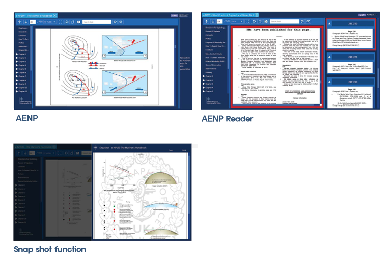
01 Overview
ADMIRALTY e-Nautical Publications (AENPs) are official ADMIRALTY Nautical Publications available as e-books. Easy to use and update, they bring improved efficiency, accuracy and access to information bridge officers need.
02 Features
AENPs are updatable, electronic versions of official ADMIRALTY Nautical Publications such as Sailing Directions (Pilots) and the Nautical Almanac. This means that bridge crews can download and apply electronic weekly Notices to Mariners (NMs) updates to publications in just a few seconds every week, improving efficiency and accuracy on board during passage planning tasks.
Simple search functionality gives users quick access to important planning information. The AENP Viewer snapshot function helps bridge crews to view, save and print AENP pages as well as any applicable NMs and addendums, which can be used to support passage planning.
01 Carriage compliance
AENPs contain the same official information as the paper equivalents that have been approved as meeting SOLAS carriage requirements by the Flag States of over three quarters of ships trading internationally.
02 Faster NM updates
Bridge crews can download and apply relevant Notices to Mariners (NM) updates in just a few seconds every week, freeing their time to focus on other important duties.
03 Aiding passage plans
Bridge crews can save and print AENP pages and any applicable NMs to include in passage plans.
04 Easier access to important information
Use the simple search function to access information more
easily and quickly than ever.
AENPs can be used on up to three computers on board,
per licence. Order AENPs from the catalogue and download
via the internet. Progress is saved as the AENP is downloaded
and will resume if your internet connection is lost.
05 Greater confidence and clarity on the bridge
The electronic weekly NM updates are added to the relevant AENPs with greater accuracy, helping to give decision makers more confidence on the bridge.